To honour a great scholar
Louis J. Scerri discusses the latest issue of the Malta Map Society Journal
Malta Map Society Journal
The Malta Map Society, Vol. 3 Issue 3, March 2026
The latest bumper number of the Malta Map Society Journal issued by the Malta Map Society is dedicated to its late honorary life president, Dr Albert Ganado.
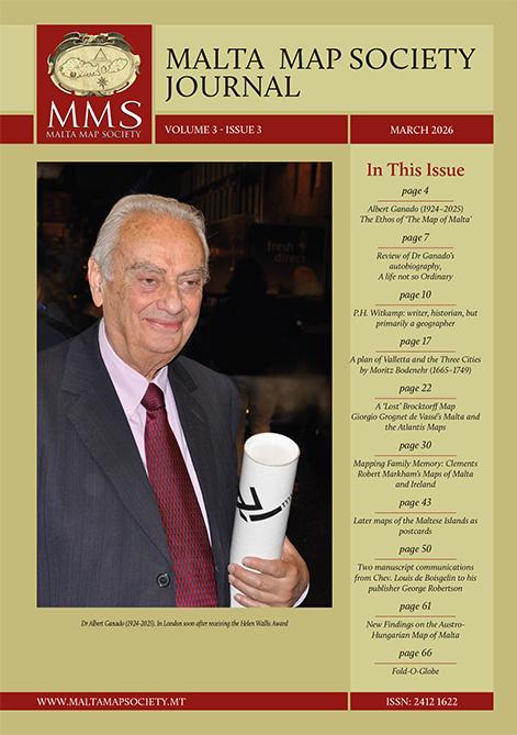
The passing away of Ganado last year was indeed a sad day for Maltese culture. God had been thankfully most generous with the years he was allotted, years which Ganado used to establish an international reputation in cartography and scholarship for himself and his country, but also to selflessly help all who turned to him for help and guidance.
Ganado has passed away, as we all are fated to do, but he lives on in the Malta Map Society which he was instrumental in founding in 2009. Thanks to a handful of dedicated fellow enthusiasts, the society lives on and has been responsible for some excellent scholarly publications that have earned recognition beyond our shores.
It is certainly beyond the scope of this short review to assess Ganado’s vast contributions, but abler hands see to it in this issue.
William Soler, Ganado’s nephew, who was bitten by the incurable Melitensia bug himself, writes a glowing account of the man whom he could often observe at close quarters. His own past collaboration with Ganado bodes well that the relevant genes have been duly inherited.
The journal also features Vladimiro Valerio’s extensive review of the English edition of Albert Ganado. A Life Not So Ordinary. The review, originally published in The Portolan, the organ of the Washington Map Society, must have been missed by local readers as it sadly was by Ganado himself, who passed away before its publication.
Following Ganado’s donation of his incomparable collection of maps of Malta, Heritage Malta has been given custody of the largest collection of maps of Malta in the world.
The back page of the journal carries a reproduction of one of Ganado’s unique treasures: the 17th-century Paris edition of the Gozitan cartographer Antonino Saliba’s map of the cosmos. This is the only known copy in the world.
Joseph Schirò, on whose able shoulders has fallen most of the task of continuing Ganado’s work, writes about an unstudied 1783 map of Valletta and the Three Cities by Moritz Bodenehr.
This schematic map emphasises the military aspects of the sites. Intriguingly, it shows a fully-fledged defensive fortification on the Ta’ Xbiex promontory.
Schirò also contributes a short account of Gerald Allen Eddy’s Fold-a-Globe, a novelty three-dimensional folding globe which described itself as “the first significant advancement in cartography in 400 years”.
In addition to having designed Mosta’s rotunda, Giorgio Grognet propounded the eccentric idea that the Maltese archipelago was the remains of Plato’s sunken city of Atlantis.
William Zammit and Schirò discuss various fantastical maps of Atlantis sited in the middle of the Mediterranean drawn by Grognet and highlight one which was lithographed by a member of the Brocktorff family.
Ivan Fsadni writes about the serendipitous discovery of two notes written by Louis de Boisgelin to his publisher about two of his books. In one he asks for his complimentary copies of his Ancient and Modern Malta, while in the other there is a typical eternal complaint of all authors about the delay in publication. Giovanni Bonello delves into his superb Melitensia collections to present post-war postcards featuring maps of the Maltese islands. Improved colour printing made possible the production of attractive coloured postcards which sometimes ended too cluttered with excessive eye-straining details included to the point of confusion.
Daniel K. Gullo writes about how Clements Robert Markham collected and mapped the drawings of his father David Markham.
Heritage Malta has acquired 29 drawings and a map of Malta by Markham carried out between 1845 and 1846.
Mario Brincat adds more information about a map of Malta published for the intelligence service of the Austro-Hungarian navy.
It now results that the map was specifically accompanied by a booklet and five other maps, all in a slipcase. Its military nature is obvious from the emphasis the booklet lays on the strengths and weaknesses of the defences of the island and notes such details as the best sites for landing troops, engineers and sappers. Marieke von Delft gives an extensive account of P.H. Witkamp, a prolific Dutch writer, historian and geographer who drew a map of the islands in 1851 for its use at schools in the Netherlands.
Copies of this limited issue can be obtained from the society. Prospective members can also join the society by writing to josephschiro60@gmail.com or to raysladden08@gmail.com.