In December 1883, Giovanni Micallef, acting superintendent, land revenue and public works, approved the plans previously submitted by senior surveyor Emanuel Galizia in May, 1880, for a proposal to erect an iron veranda near the steam ferry landing and embarkation wharf at Marsamxett, which had been entirely remodelled.
These plans superseded another submitted in 1878. The veranda was to serve as a shelter against the sun and rain for passengers using the Sliema ferry or from ships berthed in the harbour.
 Map of the fortifications of Valletta, with the Marsamxett landing indicated in red. Photo: Stephen C. Spiteri
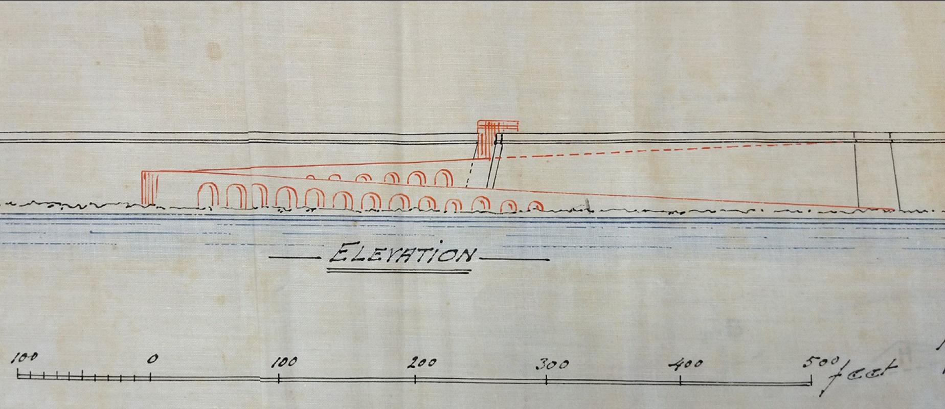
The nearby Marsamxetto or Quarantine Gate, which included a long and continuous flight of steps leading from the wharf up to Valletta, was of great inconvenience to the many people who entered or departed from this side the city. Something needed to be done, and the first proposal was for an inclined elevator or funicular that travels at an angle to carry passengers and merchandise to above the gate and vice versa.
The lift was planned to start from the landing to its station just above the old gate, situated by the military guard room. The guard room was destroyed during an air raid in World War II but the area is still referred to by locals as il-Barrakka, due to the former military post.

The proposed site for the lift station marked in red and a section showing the angle of travel of the lift. Photo: Works Department Archives

.
The project did not come to fruition. One of the reasons why it was dropped was because there were plans to eliminate Marsamxetto Gate and build an alternate and better road and gate into Valletta through the fortifications. Some 150 years later, the concept of a travelling lift from the waterside up to the fortifications above is once again being considered.
Some 150 years later, the concept of a travelling lift from the waterside up to the fortifications above is once again being considered
In May and in September 1889, Giorgio Costantino Schinas, superintendent of public works, approved two plans to breach the Marsamxett fortifications. The first plan was to create a road from the landing, along the front of San Salvatore Curtain, and rising to enter through a gate in a breach in the middle of German Curtain in front of the area known as Il-Blata. In all the walled cities, the Order of St John used to name sections of the fortifications after saints or after the nationality of the langue that defended it when needed.
The second alternative plan was to demolish part of German Curtain, build a new spur protruding seawards and a carriageway directly from the Marsamxett landing.

The proposed road into San Salvatore Bastion. Photo: Works Department Archives

Front view of the proposed breach into San Salvatore Bastion. Photo: Works Department Archives
Plan of the proposed road into German Bastion. Photo: Works Department Archives
In both plans, a new gate similar in design to Victoria Gate was proposed. One plan was to have just two large arches, while another plan was to have two large arches at the centre for vehicular traffic and small arches on each side for pedestrians. The British Royal Arms was to be at top, centre, on both. The cost of each project was to exceed £3,000, which was quite a substantial sum for the time.
 One of the proposed gates. Photo: Works Department Archives
Both these plans were reasonable with regard to conveying traffic up and down to the seashore but would have caused irreparable damage to the fortifications, a matter that was then never considered, and thankfully they were shelved.
However, the idea of a road into Valletta from the Marsamxett side lingered, and in January 1893, new plans were signed by Schinas for a similar project. This time it was to be a road connecting to San Salvatore Bastion, also known as Peacock Garden, although the origin of this name is quite obscure.
The bastion was to be breached from its right side facing the entrance to the harbour, constructing a similar road as in the previous submission, rising along the façade of the bastion as far as German Curtain at a gradient of 1 in 20, turning sharply and entering San Salvatore Bastion to connect with Marsamxetto Road. As in the earlier designs, the roads or carriageways were to be built supported by arches. Once again, the idea of such a road into Valletta was shelved.
Plan of the proposed road into German Bastion. Photo: Works Department ArchivesMaybe the reason for these proposed projects was that entering Valletta was at the time restricted to Porta Reale and Marina (del Monte) Gate, and the city was not accessible from the Marsamxett side other than by sea, and an additional venue was badly required.
In the late 1890s, new plans for a road from outside Valletta were submitted by Emanuele Luigi Galizia, who after the death of Schinas, replaced him as superintendent of public works. It was to start by the Floriana Parade Ground, passing below St Michael’s Bastion, along reclaimed ground and over the low Marsamxett fortifications, and to enter Valletta from above the Marsamxett or Quarantine Gate.
This road was to be created by constructing new supporting walls and demolishing parts of the lower fortifications below St Andrew’s Bastion. The historic and elaborate Marsamxett Gate was also to be sacrificed as the plans called for part of the road to lead to the Marsamxett ferry landing and another section of road connecting to Marsamxetto Road above the gate.

Marsamxett landing, the veranda, kiosk, marine police station and the gate in background. Photo: Richard Ellis

The Valletta side of Marsamxett Harbour with San Salvatore Bastion at centre. Photo: H. Agius
The project was completed in 1902, and Marsamxett Gate was replaced by a wider and simple tunnel to allow better access to and from the seashore. Due to the demise of the steam ferries and the increasing vehicular traffic into Valletta, Great Siege Road, as it was named, required restructuring. In the 1960s, the section leading to the landing was eliminated, although parts are still extant, and a wider and sturdier tunnel was built, which is widely used, despite being somewhat steep.
Acknowledgement
The author thanks the staff of the archives at the Works Department at the Ministry of Public Works and Planning, Belt is-Sebħ, Floriana.