Bedrock under collapsed residence ‘remains unchanged’ in latest survey
Geological map revised by British Geological Survey, minister tells parliament
Updated 4.40pm
The type of bedrock found underneath a house that collapsed in 2020 and killed Miriam Pace remained unchanged in the country’s latest geological survey in 2022, according to a government-commissioned report.
The survey contradicts claims made by geologist Peter Gatt, who questioned whether the maps had been “tampered with” to prove that the Ħamrun house did not collapse due to site geology.
The report, compiled by the British Geological Survey, was commissioned by the Continental Shelf Department.
Pace was buried in her home in March 2020 when the building collapsed as a result of excavation works being carried out next door.
Two architects responsible for the construction site have since been found guilty of involuntary homicide while others are awaiting justice.
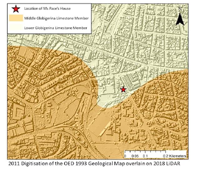
Pace’s former home was located over an area marked as middle globigerina in the 1993 geological map and all previous maps, Gatt said on his Facebook page last week. The president of the Malta Chamber of Geologists went on to claim that the same area was converted to lower globigerina limestone in the latest 2022 map.
“There is a significant difference between lower globigerina (from which we get our dimension stone) and middle globigerina limestone, a friable rock with a case history of several areas collapsing during rock excavation,” he said.
BGS report dismisses claim
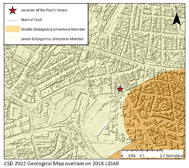
In a one-page report commissioned to respond to the claim, the British Geological Survey (BGS) said that Pace’s former home is listed as built on lower globigerina limestone in both the 1993 and 2022 geological surveys.
The 2022 map shows that more of the area in the immediate surroundings of the Santa Venera house has lower globigerina compared to the 1993 map.
BGS said the survey might not be completely accurate, especially in urbanised areas.
“Geological maps are interpretations, inferred from a variety of direct and indirect evidence, with inherent uncertainties that relate to multiple factors, including types and availability of evidence and the level of geological complexity,” the report said.
On the site itself, BGS said: “This area of Malta is urbanised, with infrastructure or housing covering most of the ground. Thus, limited natural rock exposures were observed during field mapping in this area. Evidence from the surrounding area was used to complete the geological interpretation, a common and often necessary approach in geological mapping.”
BGS said it “stands by” its interpretation of the 2022 geological map but added that more information may become available that would require a re-interpretation of the geology.
Minister asked about map
Discussion about the geological map also made it to parliament, with Finance Minister Clyde Caruana asked about it by PN MP Darren Carabott.
Carabott sought an explanation about differences between this latest map and a 1993 one.
"Can the minister explain how and why the area close to Santa Venera, Qormi and Ħamrun appear to have switched from Middle Globigerina in 1993 to Lower Globigerina in 2022?," the MP asked.
The minister responded by saying Malta's geological map was last revised in 2022 by the British Geological Survey using the latest technology
 Peter Gatt questioned why the same area where Miriam Pace's house once stood, was now marked as 'Lower Globigerina' - changed from Middle Globigerina in the 1993 survey. File photo: Times of Malta
In his detailed reply, Caruana on Wednesday said that while the 1993 map had a 1:25,000 scale, the more recent one was at a 1:10,000 ratio.
The tender for the 2022 map had been allocated to the British Geological Survey, with the work involving six foreign and one local geologist.
"The 2022 map is based on evidence available at the time of the survey, scientific research and more modern geological concepts."
The differences between the two maps are down to, among others, "changes in the placement of borders and geological structures (such as faults) that improve the relationship between geology and typography, and ensure consistency with available evidence, including on-site observations, as well as modern geological mapping practices".
"Some units were classified from scratch (such as the age of the rock) to ensure consistency with the latest scientific research."
The minister noted that the localities flagged by Carabott were highly urbanised and therefore, rock exposure was limited.
The presence of Middle Globigerina Limestone on the 1993 map is marked with a dashed line, meaning the extent of that type of rock was deducted from limited information and not geologists' direct observations, he added.